“Across our coastal zones, an estimated 2.6 billion people are exposed to climatic and oceanographic change. Data is vital for understanding our response to this change. And with it, we can forecast, we can plan, and we can unlock the finance to build coastal resilience.” These words are at the core of a speech from Tom Parry, Fugro’s global lead for coastal resilience, during the launch of CoastPredict’s Global Coast initiative.
GlobalCoast is the global coastal ocean initiative by CoastPredict, a programme endorsed by the UN Decade of Ocean Science. Its goal is to “demonstrate the value of an integrated and fit-for-purpose coastal observing and prediction system that delivers innovative products and services for coastal resilience in collaboration with local stakeholders.” The program also seeks to establish pilot sites globally, featuring virtual representations of coastal processes, utilizing data and models.
Fugro, a private company specialized in providing geotechnical and survey services, is working with the CoastPredict board to explore scientific, technical and business opportunities for collaboration between scientists, policymakers and the private sector.
“Fugro is one of the world’s leading Geo-data specialists,” says Parry, “and as a private organization, we map, model and monitor data across land and marine environments for a multitude of private sector and government initiatives.”
In this interview, Delphine Lobelle, Climate & Nature advisor at Fugro, shares insights on the importance of data collection and managing in building coastal resilience, collaboration between the public and private sectors, and the role of advanced technology and innovation in researching the global coastal ocean.
How does Fugro balance its focus on meeting market needs with pursuing innovation and contributing to global coastal resilience?
Fugro operates at the intersection of innovation and business, focusing on meeting market needs while striving to be innovative leaders. We are a global company, with 11,000 employees and 62 years of experience in geo-data. We are committed to the goals of the UN Ocean Decade, prioritizing sustainability projects that contribute to a safer, more livable world.
With a history of serving clients in marine and land interface sectors, Fugro has extensive experience in collecting and modeling environmental data. Our ongoing innovation efforts involve exploring new technologies to enhance data collection and analytics efficiency. In the context of coastal resilience, we are leveraging existing capabilities and exploring partnerships, such as our involvement in CoastPredict, to integrate various data sources and drive impactful initiatives.
How does Fugro approach collaborations with research organizations or initiatives like CoastPredict to enhance its projects?
At Fugro, we are driven by purpose and focused on delivering solutions. We understand that to develop effective solutions, they must be data-driven, leveraging the best available science for each specific application and end-user. Collaborating with researchers allows us to access cutting-edge models and data within the CoastPredict community, which is crucial for our work. In return, we contribute our expertise in data integration, cloud computing infrastructure, and front-end development. Our public-partnerships enable us to create robust end-to-end solutions for coastal zone managers and decision-makers. Overall, it’s a collaborative effort on multiple fronts.
What are the main end-users of Fugro’s datasets and products?
We have three tiers of end-users for our solutions. The first tier consists of government bodies, representing decision-makers. The second tier includes international funding institutions such as the World Bank or UNDP. Lastly, the third tier comprises insurance companies or risk management firms, which often represent infrastructure asset holders or owners.
Currently, our focus is on engaging with government entities because we believe they have the most significant impact on decision-making processes related to hazard management and coastal zone management. By collaborating with government bodies, we aim to fully understand the challenges and their current processes in order to implement effective solutions.
What is the role of developing and implementing innovative technologies, such as artificial intelligence and robots for data collection and analysis?
All our devices, including boats and underwater robots, are developed in-house. At Fugro, our primary revenue comes from collecting and providing data to our clients. We have dedicated departments for robotics and software development, where we create and manage the tools and equipment needed for data collection and analysis. We also focus on the integration of advanced technology in our systems, such as artificial intelligence.
At Fugro, we follow a triple “M” approach: Map, Model and Monitor. Mapping the coastal zone requires data collection to produce a baseline representation of built and natural assets on land and marine space. Modelling provides the insights required to make predictions of coastal hazards or seabed habitat health following future climate change scenarios. Finally, monitoring is required to detect changes of a coastal ecosystem through time relative to the mapped baseline via more frequent data acquisition.
How did Fugro come to focus on operating at the interface between land and ocean, and what factors influenced this strategic decision?
Fugro initially focused on land drilling and core characterization, later expanding into water, at the interface between land and ocean, encompassing hydrodynamics and meteorology. The so-called met-ocean concept combines monitoring, forecasting, system management, quality checks, modeling, and short and long-term weather forecasting.
This comprehensive approach integrates atmospheric and oceanic systems to provide insights and predictions for various applications. Especially with the recent focus on global energy transition, offshore wind farms require marine site characterisation, which has become the largest form of revenue in recent years.
Our focus on ocean-related initiatives was also largely driven by the UN Ocean Decade. Fugro’s involvement in projects like Seabed2030, which aims to map the entire seabed by 2030, has been instrumental. When the Ocean Decade began, only a small percentage of the seabed had been mapped, but with concerted efforts, including Fugro’s contributions in bathymetry mapping, significant progress has been made.
What are the key challenges in coastal modeling, and why is it important to address these challenges to support coastal resilience efforts?
Coastal modeling presents unique challenges due to the need for precise representation of small-scale features, typical of coasts. Unlike the open ocean where larger scale models suffice, coastal areas require high resolution to capture interactions between water and land. Until recently, modeling capabilities struggled to resolve these intricacies, leading to potential misrepresentations. However, advancements in downscaling models, like those in the CoastPredict community, offer promising solutions.
The coastal zone’s significance is underscored by the fact that around 40% of the global population resides there, with many relying on coastal resources for sustenance. Climate change exacerbates coastal hazards, affecting vulnerable regions like small island developing states and low-lying areas. This heightened risk compels decision-makers and asset owners to address coastal resilience.
By understanding coastal dynamics and providing both short-term and long-term forecasts, we empower stakeholders to adopt proactive measures. For instance, in areas like Mozambique, where frequent cyclones pose constant threats, the absence of accurate early warning systems necessitates proactive solutions. Therefore, initiatives like ours aim to bridge this gap and equip communities with tools for resilience.
Could you share any recent case studies or projects that you find particularly noteworthy and that highlight the role of data-based information for coastal resilience?
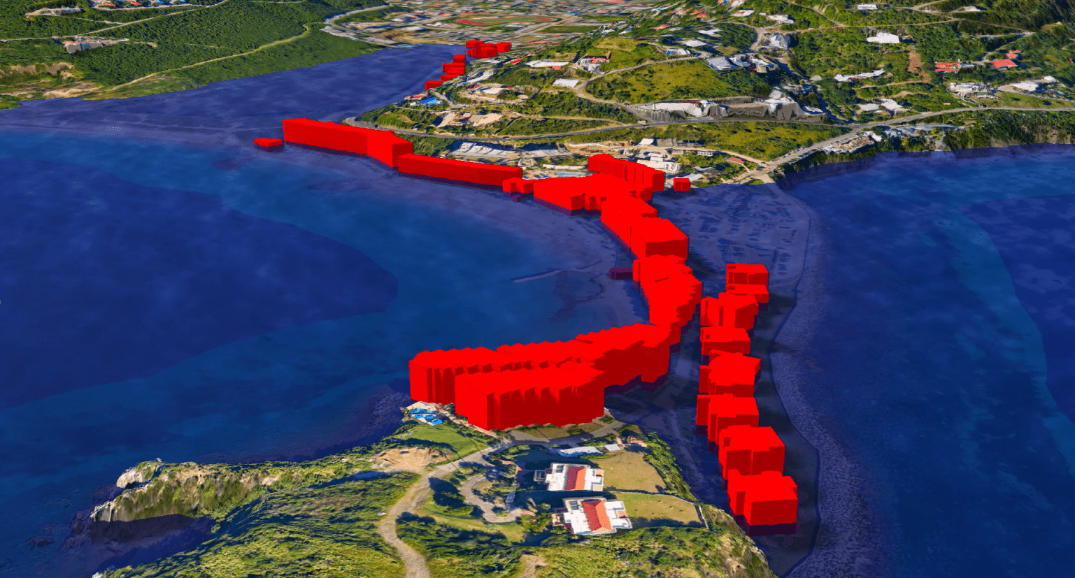
One of our primary clients has been the United Nations Development Program (UNDP) in Palau, with whom we have collaborated extensively to co-design a prototype for data collection on coastal hazards. Through interviews and workshops with the local community, we gathered feedback and insights, refining the prototype to better suit their needs. Despite being a prototype, its capability to integrate various datasets, including open-source data, into a unified platform has already produced excellent results.
Policymakers in many Pacific island nations like Palau currently rely on rudimentary methods, such as paper maps, to prepare for hazards. Our solution offers a significant advancement by providing real-time data insights, enabling proactive decision-making.
For instance, by identifying flood-prone areas based on historical data and projections, we empower stakeholders to mitigate risks and safeguard lives and assets. Our approach is not prescriptive; instead, we aim to equip decision-makers with the necessary information to make informed choices tailored to their specific circumstances and needs.
Moreover, Fugro, in collaboration with Compagnia Generale Ripreseaeree (CGR), has been selected by the Italian Institute for Environmental Protection and Research (ISPRA) to map the coastal habitats along Italy’s entire coastline. This initiative is part of the Italian government’s Marine Ecosystem Restoration (MER) Project under the National Recovery and Resilience Plan, aimed at advancing marine conservation and environmental restoration efforts in Italy.
Dr. Delphine Lobelle is a Climate & Nature Advisor at Fugro, responsible for identifying geo-data solutions for coastal zone managers and decision-makers facing challenges due to climate change impacts and ecosystem degradation around the globe. Delphine’s background is in physical oceanography, where she completed her PhD and postdoctoral research on the impacts of climate change on large-scale ocean circulation and plastic pollution modelling, respectively.