Rising sea levels is one of the risks that people most commonly associate with global warming, with more than 600 million people (around 10% of the world’s population) living in coastal areas that are less than 10 meters above sea level. A heating world leads to thermal expansion of water (water expands as it gets warmer) and land-based ice melting, which in turn brings our oceans to eat up more and more land. Finding solutions to this problem is a complex issue that requires researchers and policymakers to look at the broader picture when addressing both adaptation and mitigation measures.
“What we need is a cross-sectoral approach that faces and solves problems related to sea level rise with a systemic vision of risks that then shares possible actions between different actors. Paradoxically, if I implement adaptation actions these same actions could then create problems elsewhere and therefore lead to maladaptation,” explains CMCC researcher Silvia Torresan, whose research at the CMCC focuses on impacts, risks and vulnerability related to climate change.
Considering multiple types of hazards reduces the likelihood that risk reduction efforts targeting one type of hazard will increase exposure and vulnerability to other hazards, in the present and future.
IPCC, Special Report of the Intergovernmental Panel on Climate Change.
“Rising sea levels can lead not only to loss of beaches, land and coastal ecosystems but also problems related to salt water intrusion into freshwater aquifers and an increase in flooding due to sea surges with significant impacts on coastal cities. Furthermore, there could be a degradation of ocean ecosystems due to changes in temperature, salinity, ph levels and other biogeochemical properties of water,” She continues.
The importance of using a multi-risk approach
Evaluating risk depends on an analysis of hazard (how much sea levels will rise), exposure (who and what will be affected) and vulnerability (who and what is particularly exposed to the effects).
Therefore, the threats presented by rising sea levels must be evaluated against the specific circumstances of each area. For instance, many coastal zones are also experiencing increasing anthropic pressures linked with socio-economic development (e.g. overfishing, tourism, port activities, industrialization) and land use changes (e.g. urbanization) that compound the risks derived from rising sea levels.
Understanding how different land and sea-based drivers – natural and anthropic – shape the evolution of coastal zones at different spatial and temporal scales, and what solutions could be implemented to reduce vulnerability and mitigate environmental and socio-economic risks is of paramount importance to unlock sustainable development pathways.
Silvia Torresan, CMCC Foundation
With fellow researchers, Torresan is working on bringing this approach into policymaking, by applying a multi-criteria methodology to support the analysis and prioritization of risk management measures aimed at enhancing resilience towards climate change-related extreme events for the Metropolitan city of Venice in Northern Italy with the Savemedcoast2 project. By providing stakeholders with information on climate risks this then helped them identify the most imminent hazards and impacts.
What does this mean for policy decisions?
When talking about sea level rise, accurate predictions are fundamental for both mitigation and adaptation policies. For mitigation, knowing that different emissions pathways will have a direct effect on future sea levels can act as an added incentive for reducing emissions. For adaptation, accurate predictions and a multi-risk approach can make all the difference when choosing what strategies to adopt and where and when to apply them.
“Different scenarios, when analysed one by one, lead to a specific prioritisation of the set of risk management measures; while, when the scenarios are analysed together, the prioritisation of the same measures can be totally different. The necessity to adopt a multi-hazard approach to disaster risk management and climate change adaptation is confirmed by these outcomes developed in the Metropolitan city of Venice using a bottom-up approach with a strong stakeholders involvement in the frame of the BRIDGE project. Implementing measures strongly oriented to cope with single hazard could lead to an increase of a risk towards other kind of hazards,” explains Anna Sperotto, scientist that at CMCC Foundation who focuses her research on Risk Assessment and Adaptation Strategies.
Furthermore, processes leading to adaptation are far more effective when they are inclusive: involving actors covering different sectors, stages and domains of risks and resilience management to ensure that the needs and perspectives of minority groups are also taken into account. In this way, different system connections and interdependencies are fully understood. Finally, increasing the awareness and knowledge of specific groups of the population to climatic phenomena also makes them more supportive of adaptation policies.
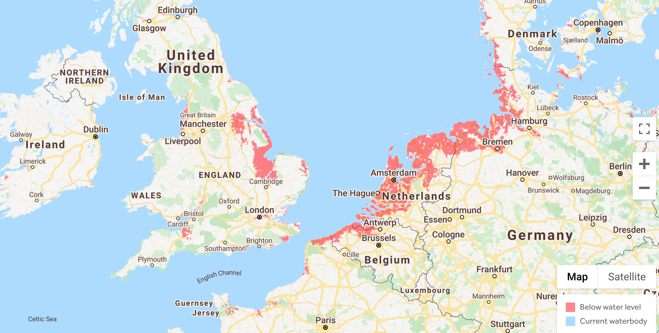
This is fundamental when talking about coastal planning around the world and not just in Venice. Moderate future scenarios indicate that by 2050 the homes of 150 million people could find themselves permanently below the high-tide line. And this is accounting for stability in the Antarctic. If on the other hand an Antarctic instability outlook is assumed then a total of 300 million people are considered as currently living on land that is at risk.
But how can governments plan for these changes? Scientists are working to assist them by providing reliable and accurate information.
How much will they rise?
Since 1880 global mean sea levels have risen by 21-24 cm, with a 3.6 millimetre rise per year between 2006-2015, which is more than twice as much as the average for the rest of the 20th century (1.4 millimetres per year). As ocean and land temperatures continue to increase scientists are certain that sea levels will continue to rise. However, the extent of this increment is still up for debate.
One source of uncertainty is the contribution of the Antarctic ice sheet. New evidence published in the journal Nature suggests that melting ice in the Antarctic alone could raise sea levels by 2.5 metres in a 2ºC warming scenario: “The ice sheet’s temperature sensitivity is 1.3 metres of sea-level equivalent per ºC of warming up to 2ºC above pre-industrial levels […] if the Paris Agreement is not met, Antarctica’s long-term sea-level contribution will dramatically increase and exceed that of all other sources”.
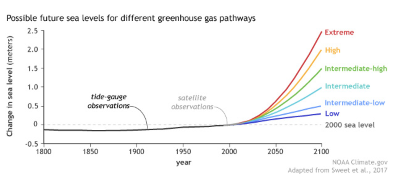
But it’s not just about Antarctica. Another peer-reviewed paper, also published in the journal Nature, predicts that anthropic emissions over the coming decades could lead to a greater rise in sea levels than previously envisioned, exposing over 300 million people’s homes to flooding and leaving over 200 million people’s homes permanently below the high tide line by 2100.
According to the IPCC SROCC by the end of the century, average global sea levels will rise by a minimum of 0.29 and a maximum of 1.1 metres, depending on the amount of greenhouse gases present in the atmosphere. “Even if we manage to reduce emissions in line with the Paris Agreement objectives, sea levels will still rise between 28 and 60 centimetres by the end of the century. For this reason, it is important to act both in terms of mitigation and adaptation”, explains Torresan.
The Summary for Policymakers for the Special Report on the Ocean and Cryosphere in a Changing Climate (#SROCC) 🌊 is now available in all UN languages:
📘 https://t.co/INhkFDKDKr
🇬🇧 🇫🇷 🇨🇳 🇪🇸 🇦🇪 🇷🇺 pic.twitter.com/fZ9bWfSAen— IPCC (@IPCC_CH) July 7, 2020
How do scientists calculate sea level rise?
The reason we are seeing updated figures and at times contrasting predictions has to do with the way in which sea level rise is calculated and the myriad of factors that must be taken into account.
There are two main ways of calculating rising sea levels. The first is through the use of tide gauges that, for over a century, have been used for measuring daily high and low tides across the globe. The other method involves satellite altimeters (utilising both radar and laser technology) that can map ocean depth more accurately. Using a mixture of these tools, scientists determine how oceans are changing over time.
However, to understand where and when sea level rise will impact specific areas and communities scientists must also collect accurate readings of land elevation against which to compare their data.
“Not only are sea levels rising but there are also vertical movements in land, due to both the movement of tectonic plates and land subsidence. Whereas for the movement of tectonic plates we do have some data on a national and global scale, land subsidence has to be calculated at a local level with precise measurements that are hard to apply on a broad scale,” explains Torresan.
Furthermore, the presence of anthropic activities can influence both land subsidence and the effects of sea level rise (for instance dams can prevent flooding from rising sea levels) leading to inaccurate data on inundation estimates, particularly in heavily developed coastal areas.
Measuring land elevation
The most commonly used instrument for evaluating land elevation in the United States is the Shuttle Radar Topography Mission (SRTM). However, it is prone to overestimations averaging around 4.7 metres in low-elevation coastal areas with high population density, such as Boston, Miami and New York.
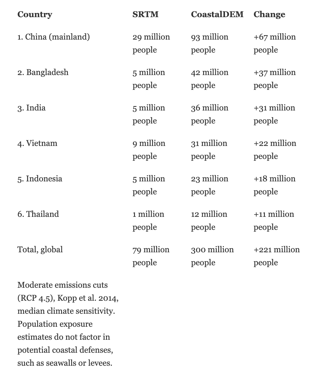
A new tool developed by Climate Central manages to lower inaccuracies when measuring land elevation to less than 6.35 centimetres. The tool called CoastalDEM reveals that in fact many of the worlds coastal areas are a lot lower than previously thought, therefore increasing the number of people that are predicted to be affected by rising sea levels. The coastal risk screening tool uses improved elevation data to provide forecasts of coastal flooding depending on different scenarios and allows anyone to create customizable and localised maps, analysing risks over time and in any given area.
Using the CoastalDEM tool researchers have found that hundreds of millions of people more than previously thought could be affected by rising sea levels. In particular, coastal Asia is vulnerable and research also indicates that in the US “sea-level rise this century may induce large-scale migration away from unprotected coastlines, redistributing population density across the country and putting great pressure on inland areas”.
The number of vulnerable provinces as well as the magnitude of vulnerability are expected to increase in the future due to the worsening of climate, environmental, and socio-economic conditions.
Elisa Furlan, Climate risk, impact and vulnerability assessment scientist at the Euro-Mediterranean Center on Climate Change.
“I am very sensitive to this issue since I live in a very fragile coastal environment that is highly vulnerable to climate change, the city of Venice and its lagoon”, explains Torresan. “However, it is important to point out that the climate central instrument doesn’t factor in dams in the Venice area so although the tool can increase awareness it doesn’t give an accurate prediction. This instrument gives a screening that identifies which areas will be more vulnerable, you cannot however use its outputs to plan in the region. To do this you need more precise and higher resolution data.”
Implementing a multi-risk approach
A new paper on risks associated with extreme sea level scenarios in Italy and how both natural and human drivers lead to both risks and vulnerability in coastal areas seeks to provide integrated knowledge and data with information on exposure and vulnerability. “We developed an improved vulnerability index that is able to represent both the overall vulnerability level of the coasts as well as disentangle the multiple dimensions of coastal vulnerability [so as to] better investigate the interconnections of climatic hazards with temporal changes in social and economic systems, as well as their relationship with the surrounding environment”, explains Elisa Furlan, impact and vulnerability assessment scientist at the Euro-Mediterranean Center on Climate Change and main author of the paper that is yet to be published.
Of particular significance is the paper’s choice to focus on the national scale so as to support policymakers by providing them with a “big vulnerability picture of Italian coasts as a whole and the vulnerability condition of individual coastal provinces. This wider spatial perspective, allows for identifying hotspot vulnerable provinces deserving prior attention and requiring more local-scale assessments to support ad hoc decision making”, continues Furlan. The paper may well be the first attempt at applying a Coastal Vulnerability Index for the entire Italian coast as opposed to focusing on more localized coastal areas.
Results indicate that “the number of vulnerable provinces, as well as the magnitude of vulnerability, are expected to increase in the future due to the worsening of climate, environmental, and socio-economic conditions (e.g. land use variations and increase of the elderly population).” By using a multi-risk approach and providing a national-scale picture of vulnerability the paper can therefore facilitate integrated coastal zone management and support climate adaptation planning that is timely and effective.

